Figura:Black Hawk Bridge Lansing 1995.jpg

Contenuti della pagina non supportati in altre lingue.
Da Wikipedia.

Archivi original(4 623 × 3 638 pontin, amzure: 3,09 MByte, sòrt MIME: image/jpeg)

Cost archivi a riva da Wikimedia Commons e a peul esse dovrà da dj'àutri proget. La descrission an soa pàgina ëd dëscrission ëd l'archivi a l'é smonùa sì-sota.

Descrission
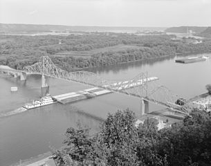
English: Aerial photo of the Black Hawk Bridge — on the Mississippi River in Lansing, Iowa.


Credits
  • This image was found at the Library of Congress HAER archive entry with the original caption: "1. 3/4 VIEW FROM TOP OF BLUFF, FROM NORTHWEST HAER IOWA,3-LANS,1-1"
  • Image taken by Joe Elliott, Summer 1995.
  • It is a part of the federal Historic American Engineering Record collection of documentation photos.


Note found on caption page

These photographs are Government material and are not subject to copyright. However, the courtesy of a credit line identifying the Historic American Engineering Record and the photographer would be appreciated.
Data estate 1995
date QS:P,+1995-00-00T00:00:00Z/9,P4241,Q40720564
Sorgiss
Questa image è disponibile presso la Divisione Stampe e Fotografie (Prints and Photographs Division) della Biblioteca del Congresso sotto l'ID digitale hhh.IA0419.
Questo tag non indica lo status del copyright dell'opera ad esso associato. È quindi richiesto un normale tag di copyright. Vedi Commons:Licenze per maggiori informazioni.

العربية  беларуская (тарашкевіца)  বাংলা  čeština  Deutsch  English  español  فارسی  suomi  français  galego  עברית  magyar  Bahasa Indonesia  italiano  日本語  lietuvių  македонски  മലയാളം  Nederlands  polski  português  português do Brasil  română  русский  sicilianu  slovenčina  slovenščina  Türkçe  українська  简体中文  繁體中文  +/−

Autor Joe Elliott (photographer)
Përmess
(Riusagi ëd cost archivi)
This file comes from the Historic American Buildings Survey (HABS), Historic American Engineering Record (HAER) or Historic American Landscapes Survey (HALS). These are programs of the National Park Service established for the purpose of documenting historic places. Records consist of measured drawings, archival photographs, and written reports.


When reusing please credit: Library of Congress, Prints & Photographs Division, HAER IA-43-1
This tag does not indicate the copyright status of the attached work. A normal copyright tag is still required. See Commons:Licensing.

Public domain This image or media file contains material based on a work of a National Park Service employee, created as part of that person's official duties. As a work of the U.S. federal government, such work is in the public domain in the United States. See the NPS website and NPS copyright policy for more information.
Luogo dello scatto43° 21′ 58,21″ N, 91° 13′ 09,8″ W Kartographer map based on OpenStreetMap.Posizione di questa e altre immagini su: OpenStreetMapinfo

Didascalie

Aggiungi una brevissima spiegazione di ciò che questo file rappresenta

Elementi ritratti in questo file

raffigura italiano

43°21'58.212"N, 91°13'9.804"W

tipo di file italiano

image/jpeg

checksum italiano

758a846f19268ff8bea1c2e62dbca737365f2336

metodo di determinazione italiano: SHA-1 italiano

dimensione dati italiano

3 245 028 byte

altezza italiano

3 638 pixel

larghezza italiano

4 623 pixel

Stòria dl'archivi

Ch'a-i daga un colp col rat ant sna cobia data/ora për ës-ciairé coma a restèissa l'archivi ant col moment-là.

Data e OraMiniaduraAmzureUtentComent
dël dì d'ancheuj01:45, 16 Aos 2011Miniadura dla version ëd 01:45, 16 Aos 20114 623 × 3 638 (3,09 MByte)Ras67{{Information |Description ={{en|1=Black Hawk Bridge, Lansing, 1995 This image was found at the Library of Congress HAER archive entry with the original caption: "1. 3/4 VIEW FROM TOP OF BLUFF, FROM NORT

Le pàgine sì-sota a l'han andrinta dj'anliure a sta figura-sì:

Dovragi global dël file

J'àutre wiki sì sota a deuvro st'archivi-sì:

Dat adissionaj