
Figura:Maricopa County Incorporated and Planning areas Scottsdale highlighted.svg

Dimension ëd costa anteprima PNG dë st'archivi SVG: 694 × 599 pontin. Àutre arzolussion: 278 × 240 pontin | 556 × 480 pontin | 889 × 768 pontin | 1 185 × 1 024 pontin | 2 371 × 2 048 pontin | 940 × 812 pontin.
Archivi original (archivi an forma SVG, amzure nominaj 940 × 812 pontin, amzura dl'archivi: 1,05 MByte)
Oget
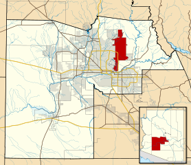
| Descrission | This map shows the incorporated areas and Indian reservation boundaries in Maricopa County, Arizona, along with water bodies and major highways and roads. Scottsdale is highlighted in red. Other incorporated cities are shown in gray, planning area borders for these cities and Indian reservation borders are shown as solid black lines. Changes from Previous Version: Updated the maps to include water bodies and to make "less boring" than the plain black/white/gray maps. Format was updated to match standards laid out by WikiProject Maps/Conventions. Map data is based on data from the following Webpage: Maricopa County Interactive GIS Map. I created this map in Inkscape. |
| Data | |
| Sorgiss | My own work, based on government information |
| Autor | Ixnayonthetimmay |
| Përmess (Riusagi ëd cost archivi) |
Public Domain |
| Àutre version | See Category:Maps of Maricopa County for other versions of this image. |
Licensa
| Mi, ël padron dij drit ëd còpia dë sto travaj-sì, i lasso sto travaj-sì ant ël domini pùblich. Sòn a s'àplica a tul ël mond. An quàich ëstat sòn a peul esse pa legalment possìbil; se parèj: I don a mincadun ël drit ëd dovré sto travaj-sì për qualsëssìa but, sensa gnun-e condission, gavà ch'a-i sio ëd condission vorsùe da la lej. |
Stòria dl'archivi
Ch'a-i daga un colp col rat ant sna cobia data/ora për ës-ciairé coma a restèissa l'archivi ant col moment-là.
| Data e Ora | Miniadura | Amzure | Utent | Coment | |
|---|---|---|---|---|---|
| dël dì d'ancheuj | 08:41, 20 maj 2011 | | 940 × 812 (1,05 MByte) | Ixnayonthetimmay | Uploading new version |
| 06:39, 30 Aos 2008 |  | 900 × 800 (413 KByte) | Ixnayonthetimmay | == Summary == {{Information |Description=This map shows the incorporated areas and unincorporated areas in Maricopa County, Arizona. [[:en:Paloma, Arizona|Pa | |
| 02:05, 16 Stè 2007 |  | 900 × 800 (384 KByte) | Ixnayonthetimmay | {{Information |Description= |Source= |Date= |Author= |Permission= |other_versions= }} | |
| 12:13, 28 maj 2007 |  | 900 × 780 (329 KByte) | Ixnayonthetimmay | ||
| 03:15, 22 maj 2007 |  | 900 × 780 (318 KByte) | Ixnayonthetimmay | ||
| 07:24, 30 gen 2007 |  | 904 × 758 (177 KByte) | Ixnayonthetimmay | {{Information |Description=This map shows the incorporated areas in Maricopa County, Arizona, highlighting Scottsdale in red. It also shows the boundaries for |
Anliure a le figure
Le pàgine sì-sota a l'han andrinta dj'anliure a sta figura-sì:
Dovragi global dël file
J'àutre wiki sì sota a deuvro st'archivi-sì:
- Usagi dzora ar.wikipedia.org
- Usagi dzora arz.wikipedia.org
- Usagi dzora br.wikipedia.org
- Usagi dzora ca.wikipedia.org
- Usagi dzora ceb.wikipedia.org
- Usagi dzora de.wikipedia.org
- Usagi dzora el.wikipedia.org
- Usagi dzora eo.wikipedia.org
- Usagi dzora eu.wikipedia.org
- Usagi dzora fa.wikipedia.org
- Usagi dzora fr.wikipedia.org
- Usagi dzora ga.wikipedia.org
- Usagi dzora gl.wikipedia.org
- Usagi dzora ht.wikipedia.org
- Usagi dzora hu.wikipedia.org
- Usagi dzora id.wikipedia.org
- Usagi dzora it.wikipedia.org
- Usagi dzora ja.wikipedia.org
- Usagi dzora kw.wikipedia.org
- Usagi dzora mg.wikipedia.org
- Usagi dzora ms.wikipedia.org
- Usagi dzora ro.wikipedia.org
- Usagi dzora sr.wikipedia.org
- Usagi dzora sv.wikipedia.org
- Usagi dzora sw.wikipedia.org
- Usagi dzora tr.wikipedia.org
- Usagi dzora tt.wikipedia.org
- Usagi dzora ur.wikipedia.org
- Usagi dzora vi.wikipedia.org
- Usagi dzora vo.wikipedia.org
- Usagi dzora www.wikidata.org
- Usagi dzora zh.wikipedia.org