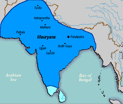
Figura:Mauryan Empire Map.gif
Mauryan_Empire_Map.gif (400 × 337 pontin, amzure: 11 KByte, sòrt MIME: image/gif)
Stòria dl'archivi
Ch'a-i daga un colp col rat ant sna cobia data/ora për ës-ciairé coma a restèissa l'archivi ant col moment-là.
| Data e Ora | Miniadura | Amzure | Utent | Coment | |
|---|---|---|---|---|---|
| dël dì d'ancheuj | 02:16, 25 mar 2016 |  | 400 × 337 (11 KByte) | LouisAragon | rv, changes made by a banned user. |
| 03:14, 23 Avr 2007 |  | 400 × 337 (11 KByte) | Jagged 85 | ||
| 01:02, 14 Dze 2006 |  | 400 × 337 (11 KByte) | Electionworld | {{ew|en|Vastu}} {{ShouldBeSVG}} ==Description== A poltical map of the Mauryan Empire, including notable cities, such as the capital Pataliputra, and site of the Buddha's enlightenment. ===Key=== Dark blue represents the extend of the Maur |
Anliure a le figure
Le pàgine sì-sota a l'han andrinta dj'anliure a sta figura-sì:
Dovragi global dël file
J'àutre wiki sì sota a deuvro st'archivi-sì:
- Usagi dzora anp.wikipedia.org
- Usagi dzora bh.wikipedia.org
- Usagi dzora bn.wikipedia.org
- Usagi dzora bpy.wikipedia.org
- Usagi dzora ca.wikipedia.org
- Usagi dzora cs.wikipedia.org
- Usagi dzora cy.wikipedia.org
- Usagi dzora da.wikipedia.org
- Usagi dzora en.wikipedia.org
- Usagi dzora eo.wikipedia.org
- Usagi dzora fa.wikipedia.org
- Usagi dzora fi.wikipedia.org
- Usagi dzora fi.wikibooks.org
- Usagi dzora fr.wikipedia.org
- Usagi dzora gu.wikipedia.org
- Usagi dzora he.wikipedia.org
- Usagi dzora hi.wikipedia.org
- Usagi dzora it.wikipedia.org
- Usagi dzora ka.wikipedia.org
- Usagi dzora ko.wikipedia.org
- Usagi dzora la.wikipedia.org
- Usagi dzora lt.wikipedia.org
- Usagi dzora lv.wikipedia.org
- Usagi dzora ml.wikipedia.org
- Usagi dzora mr.wikipedia.org
- Usagi dzora ne.wikipedia.org
- Usagi dzora nl.wikipedia.org
Varda l'usagi global dë st'archivi-sì.


