
Figura:British Isles.svg

Dimension ëd costa anteprima PNG dë st'archivi SVG: 361 × 600 pontin. Àutre arzolussion: 144 × 240 pontin | 289 × 480 pontin | 462 × 768 pontin | 616 × 1 024 pontin | 1 232 × 2 048 pontin | 1 300 × 2 160 pontin.
Archivi original (archivi an forma SVG, amzure nominaj 1 300 × 2 160 pontin, amzura dl'archivi: 154 KByte)
Oget
| Descrission |
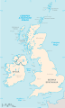
An SVG map of the British Isles, with the largest islands and archipelagos labelled. Always considered part of the British Isles
Sometimes considered part of the British Isles
Other lands |
| Sorgiss | Travaj pròpi |
| Autor | Smurrayinchester |
| SVG sviluppo | Il codice sorgente di questo file SVG non è valido a causa di 51 errori. Questa mappa in grafica vettoriale non valida secondo il W3C è stata creata con un programma SVG ignoto. This map is translated using SVG switch elements: all translations are stored in the same file. |
}
Licensa
Mi, padron dij drit d'autor dë sto travaj-sì, i lo pùblico ambelessì sota la licensa sì-sota:

|
A l'é dàit ël përmess ëd copié, distribuì e/o modifiché sto document-sì sota ij term ëd la GNU Licensa ëd Documentassion Lìbera, Version 1.2 o minca version publicà apress da la Fondassion për ij Programa Lìber; sensa gnun-e Session Anvariante, gnun Test ëd Cuvertin-a, e gnun Test ëd retro-Cuvertin-a. Na còpia dla licensa a l'é ancludùa ant la session antitolà GNU Licensa ëd Documentassion Lìbera. |
| Cost archivi a l'é sota licensa Creative Commons Atribution-Partagi ugual 3.0 nen trasportà | ||
| ||
| Sta tichëtta ëd licensa a l'é stàita giontà a cost archivi com part ëd la modìfica ëd licensa ëd GFDL. |
Derivative works
-
 македонски
 -
 Flag map (1801–1922)


derivative works
Derivative works of this file: British Isles mk.svg
Stòria dl'archivi
Ch'a-i daga un colp col rat ant sna cobia data/ora për ës-ciairé coma a restèissa l'archivi ant col moment-là.
| Data e Ora | Miniadura | Amzure | Utent | Coment | |
|---|---|---|---|---|---|
| dël dì d'ancheuj | 17:33, 10 Fër 2019 | | 1 300 × 2 160 (154 KByte) | MSG17 | Uploaded from SVG Translate. |
| 16:56, 13 Otó 2018 |  | 1 300 × 2 160 (141 KByte) | Seb35 | small bug: translations have to be before the default text else the PNG rendering selects the default text | |
| 16:51, 13 Otó 2018 |  | 1 300 × 2 160 (141 KByte) | Seb35 | added French translation | |
| 16:50, 20 maj 2014 |  | 1 300 × 2 160 (135 KByte) | NikNaks | More cleaning. File could still be a lot smaller than it currently is | |
| 05:02, 20 maj 2014 |  | 1 300 × 2 160 (152 KByte) | NikNaks | Malay translation | |
| 04:36, 20 maj 2014 |  | 1 300 × 2 160 (148 KByte) | NikNaks | Cleaning unfortunately lost detail. Will have to return to later | |
| 04:22, 20 maj 2014 |  | 1 297 × 2 160 (37 KByte) | NikNaks | Attempting to clean up the file before translation | |
| 14:37, 20 Aos 2006 |  | 1 297 × 2 160 (196 KByte) | Smurrayinchester | An SVG map of the British Isles, with the largest islands and archipelagos labeled. {{legend|#fff0de|Always considered part of the British Isles|border=#ffffff}} {{legend|#ffb380|Sometimes considered part of the British Isles|border=#ffffff}} {{legend|#e |
Anliure a le figure
Le pàgine sì-sota a l'han andrinta dj'anliure a sta figura-sì:
Dovragi global dël file
J'àutre wiki sì sota a deuvro st'archivi-sì:
- Usagi dzora ar.wikipedia.org
- Usagi dzora az.wikipedia.org
- Usagi dzora be.wikipedia.org
- Usagi dzora bs.wikipedia.org
- Usagi dzora ceb.wikipedia.org
- Usagi dzora ckb.wikipedia.org
- Usagi dzora da.wikipedia.org
- Usagi dzora en.wikipedia.org
- Geography of the Isle of Man
- Burhou
- Talk:International Football Association Board
- Module:Location map/data/British Isles/doc
- List of offshore wind farms in the Irish Sea
- Siege of St Andrews Castle
- User:Malpass93/sandbox
- Module:Location map/data/British Isles
- 2014 Senior Open Championship
- 2017 Senior Open Championship
- 2018 Eisenhower Trophy
- User:Grover cleveland/History of the laws of the game/List of IFAB meetings
- User:Grover cleveland/English managers
- 2018 Espirito Santo Trophy
- 1965 European Amateur Team Championship
- 1975 European Amateur Team Championship
- 1981 European Amateur Team Championship
- 1989 European Amateur Team Championship
- 1997 European Amateur Team Championship
- 2005 European Amateur Team Championship
- 2007 European Amateur Team Championship
- 2009 European Amateur Team Championship
- 1971 European Ladies' Team Championship
- 1979 European Ladies' Team Championship
- 1987 European Ladies' Team Championship
- 1991 European Ladies' Team Championship
- 2013 European Ladies' Team Championship
- 2021 European Ladies' Team Championship
- 2022 European Amateur Team Championship
- 2022 European Ladies' Team Championship
- 2013 Senior Open Championship
- 2012 Senior Open Championship
- 2011 Senior Open Championship
- 2008 Senior Open Championship
- 2006 Senior Open Championship
- 2002 Senior British Open
- 2001 Senior British Open
- 2000 Senior British Open
- 2022 Senior Open Championship
- User:Erik Sergeant/sandbox 2
- 2023 Senior Open Championship
- Module:Location map/data/British Isles/sandbox
- Draft:2024 Monoposto Championship
Varda l'usagi global dë st'archivi-sì.