
Figura:Ykfairportmap.png
Amzure dë sta preuva: 598 × 600 pontin. Àutre arzolussion: 239 × 240 pontin | 479 × 480 pontin | 1 000 × 1 003 pontin.
Archivi original (1 000 × 1 003 pontin, amzure: 330 KByte, sòrt MIME: image/png)
Oget
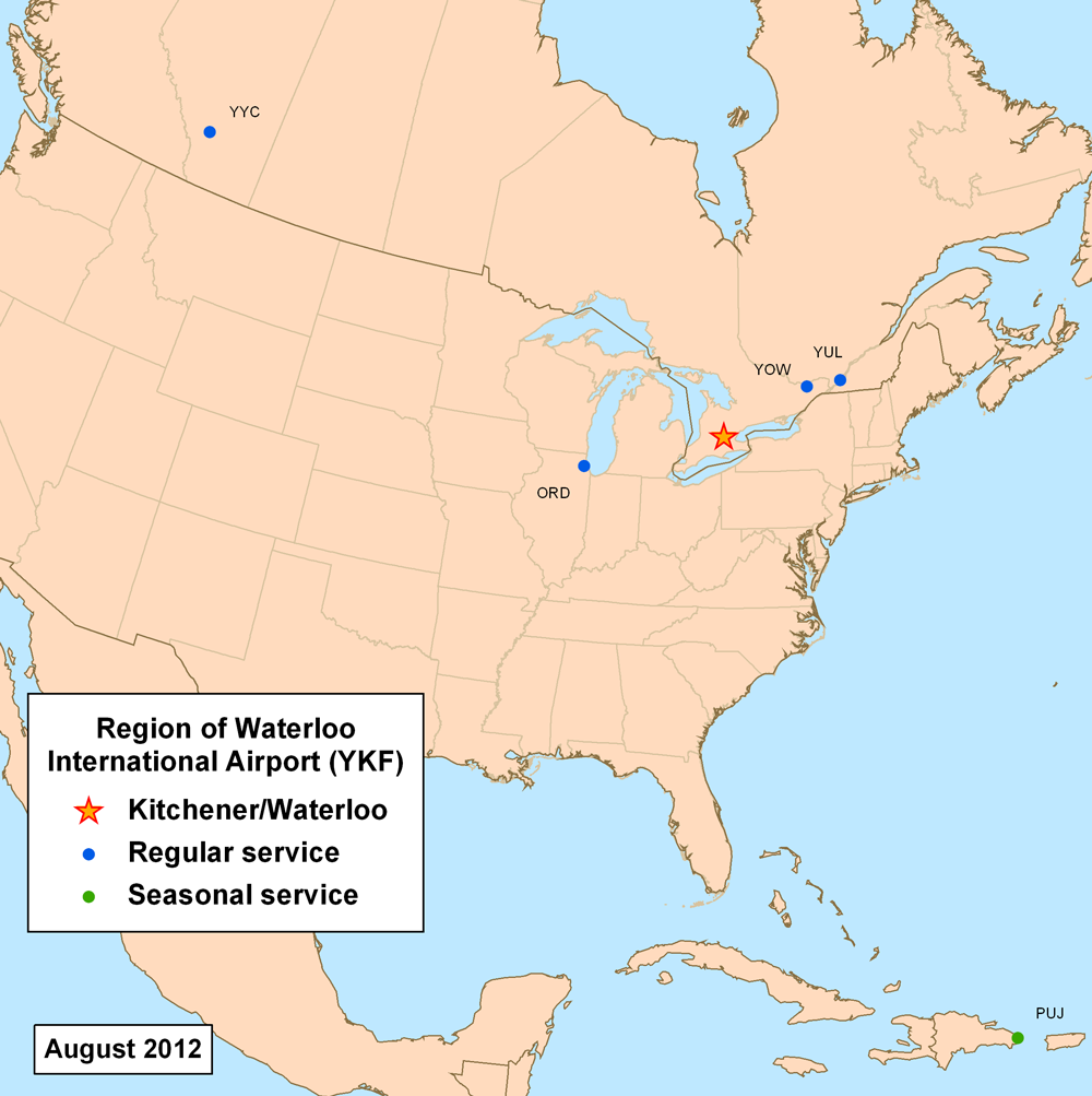
| Descrission | This is a route map for Region of Waterloo International Airport as of June 2010. Map is an Azimuthal equidistant projection centered on the airport so straight lines are along great circle routes. Source. |
| Data | 27 giugn 2007 (data di caricamento originaria) |
| Sorgiss | No machine-readable source provided. Own work assumed (based on copyright claims). |
| Autor | No machine-readable author provided. Kmusser assumed (based on copyright claims). |
Licensa
Mi, padron dij drit d'autor dë sto travaj-sì, i lo pùblico ambelessì sota la licensa sì-sota:
Cost archivi a l'é sota licensa Creative Commons Atribution-Partagi ugual 3.0 nen trasportà
- Chiel a l'é lìber:
- ëd partagé – ëd copié, distribuì e fé giré cost travaj
- ëd riorganisé – d'adaté ël travaj
- Sota le condission sì-dapress:
- atribussion – A dev dé ij credit aproprià, dé n'anliura a la licensa e indiché s'a son ëstàit fàit dij cambiament. A peul fé sòn an qualsëssìa manera rasonèivola, ma pa an na fasson ch'a sugerissa che l'autor a apreuva chiel o sò usage.
- partagi ugual – Se chiel a modìfica, a cangia, o as basa ansima a 's travaj, a deuv distribuì soe contribussion sota l'istessa licensa o a na licensa compatìbil con l'original.
Stòria dl'archivi
Ch'a-i daga un colp col rat ant sna cobia data/ora për ës-ciairé coma a restèissa l'archivi ant col moment-là.
| Data e Ora | Miniadura | Amzure | Utent | Coment | |
|---|---|---|---|---|---|
| dël dì d'ancheuj | 15:04, 27 giu 2012 | | 1 000 × 1 003 (330 KByte) | Kmusser | updated destinations |
| 23:17, 1 Fër 2010 |  | 1 000 × 1 002 (379 KByte) | Kmusser | updated destinations | |
| 15:17, 24 Stè 2007 |  | 500 × 500 (125 KByte) | Kmusser | added Ottawa | |
| 15:09, 28 giu 2007 |  | 500 × 500 (119 KByte) | Kmusser | changed Calgary to regular service | |
| 19:53, 27 giu 2007 |  | 500 × 500 (126 KByte) | Kmusser | increased dot size slightly | |
| 19:46, 27 giu 2007 |  | 500 × 500 (118 KByte) | Kmusser | == Summary == This is a route map for Region of Waterloo International Airport as of June 2007. Map is an Azimuthal equidistant projection centered on the airport s |
Anliure a le figure
Le pàgine sì-sota a l'han andrinta dj'anliure a sta figura-sì:
Dovragi global dël file
J'àutre wiki sì sota a deuvro st'archivi-sì:
- Usagi dzora en.wikipedia.org